What’s in a line?
Where do you start in a straight line? There are two beginnings, two ends, and an endless temporal present.
At every infinite point, another infinite place. Infrastructure, now “infrastruktur” in Malay, was originally rendered as the tongue-twisting “asasusunan,” a fusion of the two root words of asas (‘basic’ or ‘original’) and susunan (‘arrangement’).
Infrastructure tethers foundation to origin. Where we begin is where we are from.
Lines on a page. The past is a map.
Kuala Lumpur began
[2] “Kuala Lumpur began as a shop. On the banks of a river, connected and connecting, the city began as a shop. And people came from all parts of the East and then the West. I retrace an ancient cycle as I find the city for the first time. My primal image of this city is its primal essence, for my experience of Kuala Lumpur began with the Mall. Malling, as I named the act of wandering aimlessly around the innumerable shopping centres that sprout up everywhere like secondary jungle undergrowth, has taught me and opened my eyes to much of what I know about the city. Kuala Lumpur began as a late expression of the history that formed it… Connected and connecting KL describes all the cycles and circles enfolding the past, the present and the future.” Ziauddin Sardar, The Consumption of Kuala Lumpur, (London: Reaktion Books, 2000) 75.
as a mall. Or rather, as a trading point, the mall’s 19th-century prototype. In the 1850s, it was a small hamlet at the confluence of the Klang River and the Gombak River, with the port of Klang. But its fortunes turned when the tin mines of Ampang and Ulu Klang opened to its right. By 1880, the Selangor state capital had been moved from Klang to Kuala Lumpur. The town quickly became an important supply collection and dispersal point, supposedly the highest point that supplies could be brought by boat.
[3] J. M. Gullick, “Kuala Lumpur, 1880-1895,” Journal of the Malayan Branch of the Royal Asiatic Society 28, No. 172, (1955): 9.
To attempt to travel by land was at best, extremely uncomfortable, and at worst, physically perilous and malarial.
[4]
Frank Swettenham, as quoted in Gullick, “Kuala Lumpur, 1880-1895,” 9.
If the history of Singapore is written in statistics,
[5] J. M. Gullick, “Kuala Lumpur, 1880-1895,” Journal of the Malayan Branch of the Royal Asiatic Society 28, No. 172, (1955): 9.
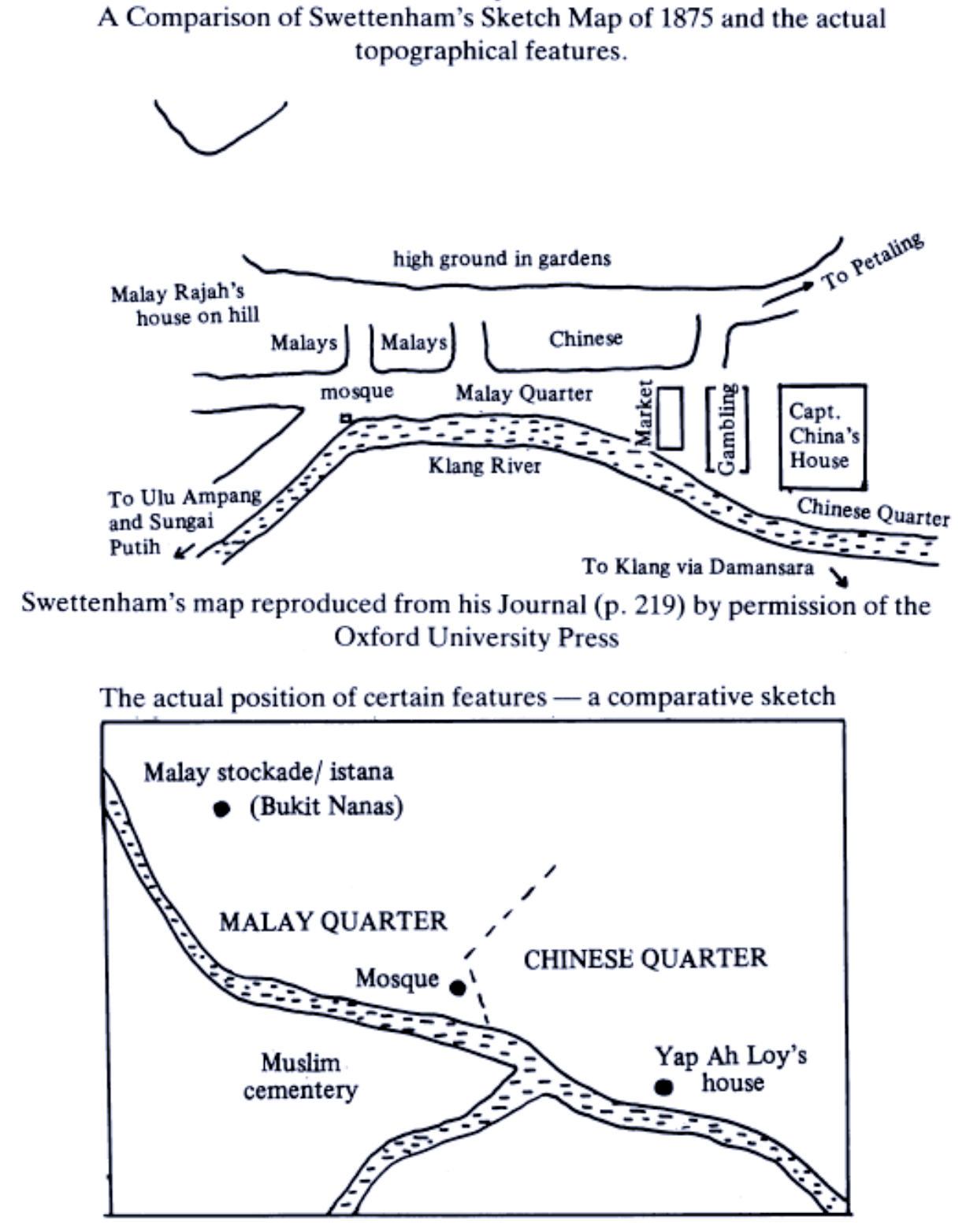
then the history of Kuala Lumpur is drawn in lines. By 1882, Frank Swettenham was appointed the third British Resident of Selangor. Swettenham’s 1875 sketch
[6]
J.M. Gullick, “The Growth of Kuala Lumpur and the Malay Community in Selangor Before 1880,” Journal of the Malayan Branch of the Royal Asiatic Society 63, No. 1, (1990): 19.
notes his biases.
[7]
Frank Swettenham’s Malay Sketches (London: J. Lane, 1903) disappointingly contained no actual sketches. Just racist caricatures. ❐
The Gombak River, which leads north further up the state of Selangor, was erased from the picture; only the Klang River, which snakes its way to the port, out of the inland remains. This exclusion belies the territorial politics at play. Goods made inland would be brought by boat to Klang, which in turn was the point of access to the Straits of Malacca. The river valley was a chokepoint: whoever controlled the river valley therefore commanded the entirety of the Klang River basin, including where Kuala Lumpur stands today. Removing the Gombak River was an excision of noise: in Swettenham’s colonial logic of capital, geography is rendered in terms of power,
[8] Jefferi Hamzah Sendut, “Wawasan 2020 and the Contradictions of Postcolonial Statehood,” (2021). ❐
not natural formation. Other points of interest on Swettenham’s map: Chinese Kapitan’s (Yap Ah Loy’s) house, market, gambling dens, mosque. Through the river, escape from sin, decay,
[9] “Sĕlângor is a most wretched place–worse than Klang. On one side of the river there is a fishing village of mat and attap hovels on stilts raised a few feet above the slime of a mangrove swamp; and on the other an expanse of slime, with larger houses on stilts, and an attempt at a street of Chinese shops, and a gambling-den, which I entered, and found full of gamblers at noonday. The same place serves for a spirit and champagne shop. Slime was everywhere oozing, bubbling, smelling putrid in the sun, all glimmering, shining, and iridescent, breeding fever and horrible life; while land-crabs boring holes, crabs of a brilliant turquoise-blue color, which fades at death, and reptiles like fish, with great bags below their mouths, and innumerable armor-plated insects, were rioting in it under the broiling sun.” Isabella Bird, The Golden Chersonese and the Way Tither (New York: G. P. Putnam’s Sons, 1883). ❐
and the reality of plantations, bringing materials made commodity to the world of the market. Modernity emerged out of the jungle.
However, this new town was structurally fragile. Successive floods and fires ravaged most of the buildings in the city centre: 1881 was an especially disastrous year, which started with a fire in January and ended with a flood on December 21. The fire began when an oil lamp fell in an opium shop, killing three people and leaving another 500 homeless, while the flood started when heavy rain caused the Klang River to overflow, destroying 92 buildings and the only bridge in Kuala Lumpur. As a result, dirt and disease were rampant, as were crises of homelessness.
[10] Shapriza Sharif and Arba’iyah Mohd Noor, “The Brick-making Industry in Kuala Lumpur in the Late Nineteeth Century,” Journal of the Malayan Branch of the Royal Asiatic Society 90, No. 1, (2017): 62. ❐
But Kuala Lumpur could be engineered and architect-ed into possibility. In 1884, Swettenham instituted building regulations, which called for structures to be built in brick, stone, and tiles. Flimsy mud walls and attap thatch roofs – which were vulnerable to the elements could not aspire to permanence – were replaced with brick and tiles. Narrow streets, some only 12’ wide, were widened and shaded arcades now known as five-foot-ways were added. The messy agglomerations of housing units were ordered into regular lines. Kuala Lumpur, wrote Governor Frederick Weld, “is fast becoming the neatest and prettiest town… Rows of sufficiently regular, yet picturesque houses and shops… form the streets.”
[11] Frederick Weld, as quoted in Gullick “The Growth of Kuala Lumpur and the Malay Community in Selangor Before 1880,” 45.
Swettenham also initiated the construction of a series of government buildings, including the Government Offices (1894-7), now known as the Sultan Abdul Samad Building.
[12]
Gullick “The Growth of Kuala Lumpur and the Malay Community in Selangor Before 1880,” 35.
R. A. J. Bidwell, a young architect of twenty-four, prepared the drawings under C. E. Spooner, the head of the Public Works Department who instructed him to make a building of “Mahametan” style.
[13] While the building is commonly attributed to A. C. Norman (a Royal Institute of British Architects accredited Government Architect) and A. B. Hubback of the Public Works Department, John Gullick has shown that it was, in fact, R. A. J. Bidwell who prepared the drawings under the guidance of C. E. Spooner, with contributions from Hubback after Bidwell left Selangor in 1895. Then, as now, RIBA certification was important for credit.
The Government Offices were unlike any building ever seen in Malaya but mimicked the Indo-Saracenic style pioneered in Indian colonial buildings that marked India’s transition to direct rule as a Crown Colony.
[14]
L: The Government Office, now the Sultan Abdul Samad Building, in Kuala Lumpur (1894-7). Image from the Farish Noor postcard collection, Malaysia Design Archive.
R: The countdown clock to the 1998 Commonwealth Games, reconstructed by Dennis Ong. It has since been demolished. The countdown clock was mere steps away from the clocktower on Jalan Raja, located in front of a building separate from the Government Office, but part of the same building complex.
Ornamentally, it drew from the language of Egyptian, Moorish, and Mughal architecture, but its front elevation was solidly symmetrical, a nod to the British neo-classicism that dominated public buildings. Never mind that the Indo-Saracenic was seen to be a union of “European science” and “native art”,
[15] Sir Richard Temple in discussion of Major C. Mant of the Royal Engineers, Transactions of the Royal Institute of British Architects, 1st series, vol. XXXII (1881-82), 104. As quoted in Thomas R. Metcalf, “Architecture and the Representation of Empire: India, 1860-1910,” Representations no. 6 (Spring, 1984), 56.
even though there was nothing native to Malaya about Egyptian, Moorish, or Mughal ornaments.
To the architects of the Public Works Department, a line directly connected its colonies in the East, roughly bisecting the Orient and the West. Within this vast space, styles could be borrowed and remixed across time and space.
[16]See more productive misunderstandings, said with much authority, in James Fergusson, History of Indian and Eastern Architecture, 2nd Edition (1910). London: J. Murray. First published 1876.
In this way, “Eastern” architecture could enter the teleology of British rule. As Thomas Metcalf has noted, the creation of the “Indo-Saracenic” was not an attempt to describe buildings, but rather, by “lumping these historic structures under a common label together with their own, the British endeavoured to lay claim to a direct line of descent from the Rajputs and Mughals to themselves.”
[17]Metcalf, “Architecture and the Representation of Empire: India, 1860-1910,” 53.
The lines that make a map, the lines that connect across a map, the lines of drawing on a page. The Indo-Saracenic, like the architectures that follow, is a myth of origin. It’s just another beginning.
“History? What history? We are creating fiction, Yatim. This is fiction. History is fiction.”
“What about historical truth, Mano?”
“… You can screw around with history, lah!”
- Kee Tuan Chye, We Could **** You Mr. Birch (1995)
Lines drawn in an instant. The future is a simulator.
Nearly a century later, in 1972, a Brit would once again land on the shores of Kuala Lumpur and draw some lines. The radical architecture collective Archigram
[18]The newsletter Archigram (a portmanteau of ‘architecture’ and ‘telegram’) was founded in 1961 and was later formalised into the architecture collective Archigram. They worked mostly in drawings and media, and were known for creating urban megapolises for a technological age. The six members of Archigram were Warren Chalk, Peter Cook, Dennis Crompton, David Greene, Ron Herron, and Michael Webb. See more in Simon Sadler, Archigram: Architects Without Architecture (Cambridge: MIT Press, 2005).
had been commissioned to design the Malaysia Pavilion at the Commonwealth Institute in London, and one of their members, Dennis Crompton, was surveying the young nation in a ten-day tour of the peninsula.
Like the Government Offices, authorities in Malaysia rejected the original approach of a more conventional design for the Malaysia Pavilion. The Commonwealth Institute, formerly the Imperial Institute, housed pavilions from former colonies of the British Empire, picturing the world for a British audience. The exhibits were constantly shifting with political developments, with updates to the Malaysian pavilion upon Sabah and Sarawak’s agreement to found the Federation of Malaysia and upon Singapore’s departure. James Gardner, the Institute’s go-to museum and exhibition designer, designed the early 1964 Malaysia Pavilion. Information was conveyed rather directly, with images and words illustrated on mounted panels, display models, and a kite hovering above it.
[19]
Flying kites, based on the wau, are common tropes to convey “Malaysianness.” This image is from the Wawasan 2020 Collection at Malaysia Design Archive.
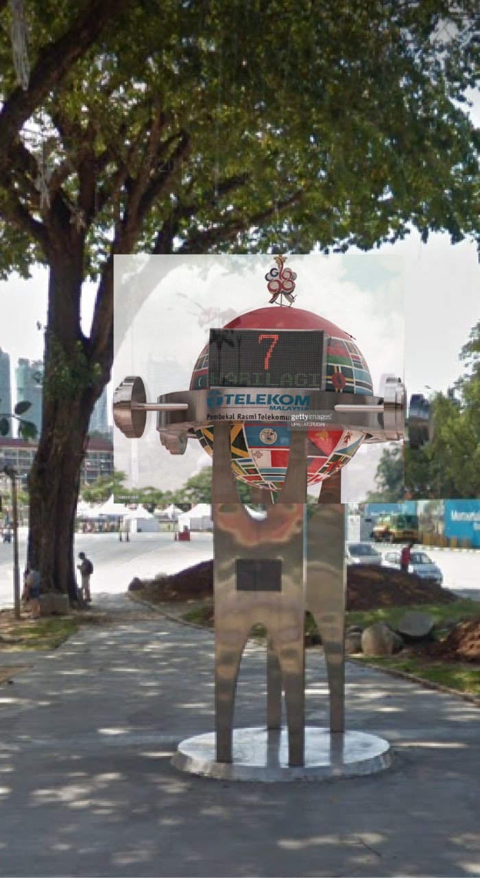
However, by 1972, Malaysia’s international image as a modern nation had been eroded by two major events: the 1972 oil crisis and the 1969 sectarian violence that spread like wildfire through the streets of Kuala Lumpur.
[20]
Jalan Tun Perak in Kuala Lumpur in the aftermath of the May 13, 1969, riots. Jalan Tun Perak historically marked the division between Malay and Chinese quarters in the early days of Kuala Lumpur. This image was taken by the then constitutional head of state, HRH Sultan Ismail Nasiruddin Shah, who was well known as a photographer.
❐
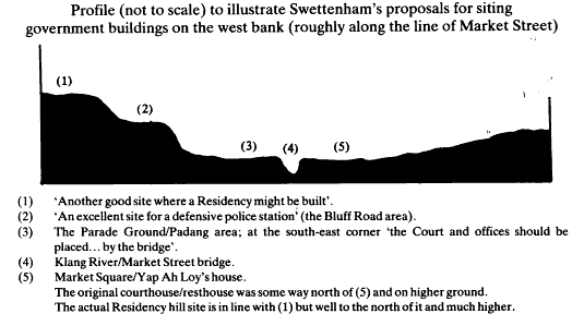
Then-Prime Minister Tun Abdul Razak, known as Bapak Pembangunan (‘the father of development’), deemed the old pavilion insufficient for Malaysia’s global aspirations.
[21]Chee-Kien Lai, “Concrete/Concentric Nationalism: The Architecture of Independence in Malaysia, 1945–1969”, PhD dissertation, (University of California Berkeley, 2005), 332-4.
Archigram’s pavilion was a remedy. Tun Abdul Razak understood that media built nations
[22]See more in Benedict Anderson, Imagined Communities (London: Verso Books, 1991), Ernest Gellner, Nations and Nationalism (Ithaca: Cornell University Press, 1983). For Malaysia-specific literature, see more in John Postill, Media and Nation Building: How the Iban Became Malaysian, (New York: Berghahn Books, 2008).
and thus galvanized a wide range of its state apparatus in service of the pavilion, including the Visual Production team from the Ministry of Information, the Ministry of Foreign Affairs, and the Malaysia High Commission of London.
[23] Kelvin Chuah, “Instant Malaysia: Imagining a Nation at the Commonwealth Institute,” British Art Studies 13. ❐
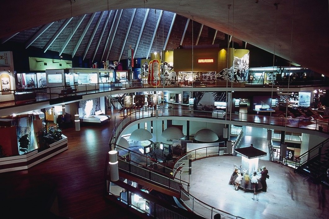
The production of an Instant was contingent on months of bureaucratic management. In return, Archigram’s Instant Malaysia would not merely be modern: it would be radical. Three Archigram members, Dennis Crompton, Ron Herron, and Ken Allinson, worked on the project. Instant Malaysia, completed in 1973, is one of the collective’s few built projects.
Instant Malaysia was maximalist. Painted a banana yellow, it towered over its “conventionally tasteful”
[24]“Archigram as Architects,” Architectural Design (1974): 387–388. Project by Centre for Experimental Practice, “Malaysian Exhibition”, Archigram Archival Project (2010), University of Westminster. ❐
neighbours, the Hong Kong and Brunei pavilions. A glowing red neon sign “MALAYSIA” welcomed visitors.
[25]
Tim Street-Porter, “Instant Malaysia” exhibition, 1973, installation photograph. Collection of the Archigram Archival Project (166-203-TC01). ❐
The exhibition had two levels,
[26]
Axonometric of the exhibition. Project by Centre for Experimental Practice, “Malaysian Exhibition”, Archigram Archival Project (2010), University of Westminster. ❐
which in earlier drawings, were meant to be brought together by a double-storey palm tree,
[27]
Project by Centre for Experimental Practice, “Malaysian Exhibition”, Archigram Archival Project (2010), University of Westminster. ❐
as if in a satirical refashioning of Laugier’s primitive hut.
[28]
The frontispiece of Marc-Antoine Laugier’s Essai sur l'Architecture, by Charles-Dominique-Joseph Eisen. Image from Wikimedia Commons.
The ground floor of the pavilion was made in the logic of the collage, bringing together disparate elements into the same space of the nation, a microcosm for the metaphor of the multi-ethnic Malaysia. The exhibition space was divided into six sections – “people”, “education”, “development”, “tourism”, “industry”, and “organized industry” – and showed texts, maps, charts, models, photographs, and the aforementioned trees, now reduced in size such that it sat within the box of the exhibition and rendered with more realism. Unlike the pleasing panels of the Gardner exhibit, Instant Malaysia married Archigram’s signature bold graphics with as many images as possible. It was an experience of everything-at-once, bringing together images, drawings, text that were “parts life-size, monster-size, micro-size, coloured, monochrome, photographic, drafted, sonic, illuminated, fabricated, ephemeral, solid, permanent.”
[29] “Malaysia Pavilion – Commonwealth Institute, London,” Domus No. 535, (May 1974), 28-29. As quoted in Lai, “Concrete/Concentric Nationalism.”
Information and noise co-existed, made legible and circulated into a familiar graphic system. Archigram was the mediator that would “consolidate, transmit, filter, and catalyze a changeable flow of information, energy and images.”
[30]Craig Buckley, Graphic Assembly: Montage, Media, and Experimental Architecture in the 1960s, (London and Minneapolis: University of Minnesota Press, 2019), 79.
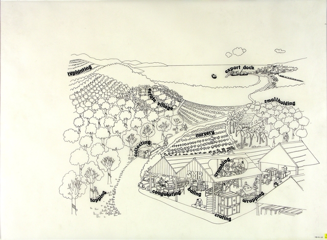
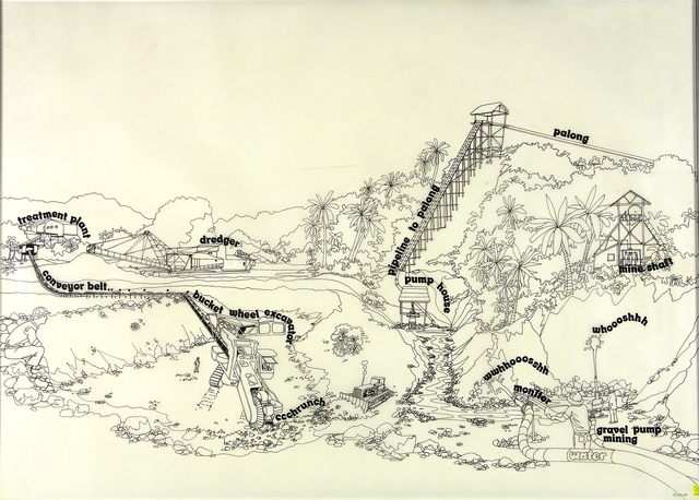
Of particular note from the project archive are early drawings for the wall illustrations, likely drawn from Dennis Crompton’s travels in Malaysia. These, for unknown reasons, were never incorporated into the final exhibition. In a comic-like remake
[31]Denise Lai, Philip, Pang, Syukri A Rahim, Victoria Yam, “Mega 2020,” (2021). ❐
of Malaysia’s primary industries, commodity is cartoon. Timber logging, harvesting palm oil, rubber tapping,
[32]
Project by Centre for Experimental Practice, “Malaysian Exhibition”, Archigram Archival Project (2010), University of Westminster. ❐
and tin mining are reduced to line and caption. In the drawing on tin,
[33]
Project by Centre for Experimental Practice, “Malaysian Exhibition”, Archigram Archival Project (2010), University of Westminster. ❐
gravel pumps and water “whooooosh” in onomatopoeic orchestration, its Comic Sans-adjacent font belying the monotonous thud of arms spinning shovels and the crunch of metal-on-metal of moving vast amounts of sand. Perhaps these lines had made the nation too legible, too uncomplicated. Beneath each drawing lay a violence of unspoken resource extraction
[34] Pantai Remis landslide on 21 October 1993, in Perak, Malaysia. ❐
inherited from a British colonial economy.
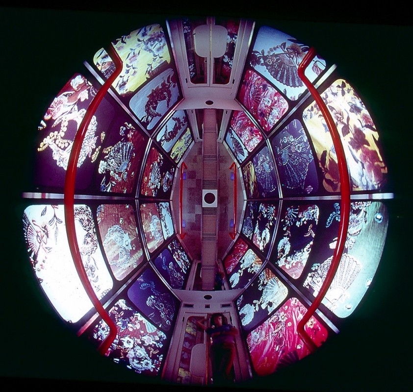
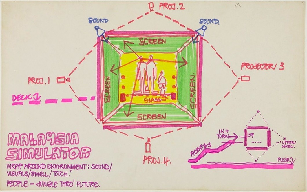
The simulator
[35]
Tim Street-Porter, “Instant Malaysia” exhibition, inside the simulator, 1973, photograph. ❐
on the second floor, however, was the clear protagonist of the exhibition – at least, according to the architects. “Rightly or wrongly, this particular piece of hardware is much more intriguing than the content of the exhibition as a whole,” wrote Archigram.
[36]"Archigram as Architects."
The simulator was a roughly ovular capsule that fitted around fifteen people, its ceiling covered with a mirror. Inside the simulator, “in 12 minutes you experience the 90º atmosphere of the Malay jungle and the cool winds after the monsoon’,”
[37]"Archigram as Architects."
with a three-track recording playing while images were projected onto the walls and reflected onto the mirrored ceiling. Crucially, the simulator had a climactic component, reproducing the range of Malaysia’s climate, “from cool sea breezes to humid heat and tropical storm.”
[38]Malaysia, Singapore, Hong Kong and Brunei - A teacher's guide to study resources published by the Commonwealth Institute. Seen in Lai, “Concrete/Concentric Nationalism,” 339.
Visitors in London thus stood in the middle of a platform, surrounded by a panorama of multiple screens, harkening back to turn-of-the-century cycloramic paintings picturing cities and war. The recurring motif of the simulator was the Malaysian flag, juxtaposing the icon with images of life in Malaysia – from airplanes, architecture, forestry, dams, mosques, people, scenery, shadow puppets, etc.
The simulator has largely been interpreted as an attempt to transport someone in London to Malaysia; that is, it is seen to be in mimicry of the tropics.
[40]See more in Chee-Kien Lai, “Concrete/Concentric Nationalism,” and Kelvin Chuah, “Instant Malaysia.”
However, a wider examination of Archigram’s work suggests that the simulator was less an attempt at imitation than an attempt to push the boundaries of space.
By the 1970s, Archigram had become less interested in physical structures than in a “subject’s relationship to audiovisual telecommunication networks.”
[41]Buckley, Graphic Assembly, 73.
While Archigram’s earlier projects involved physical movement within a network structure, their work began to emphasize the regulation of the movement of media information, such as “electronic data transmission, traffic control, and administration, radio-telephone tower, communication and news service relay station, inter-commercial closed-circuit television hook ups, public television and telstar rediffusion centre.”
[42]Warren Chalk and Ron Herron, “City Interchange – Project,” Living Arts 2 (1963): 73, as quoted in Mark Wigley, “Network Fever”, Grey Room no. 4 (Summer 2001), 108.
As David Greene, the group’s poet, wrote in reference to Archigram’s well known “Plug-In City”:
Plugging-in, however, describes an attitude, not a style, a way of thinking that shows a shift of interest from building to the device. A shift from aesthetics to the way portable hardware restructures our behaviour.
The simulator was a hardware prosthetic. Plugged in, it allowed “the extension of one medium into another and a corresponding enlargement of consciousness into a new spatial condition.”
[43]Buckley, Graphic Assembly, 78.
The acceleration of time and space in an age of modernism had become so fast as to shrink time-lags to virtually nothing: hardware was an instrument for temporal and spatial reduction. Being modern was not enough, Malaysia could be produced in a priori brevity, in an instant. Instant information, instant affect, instant sound, all brought to life through the simulator.
But the pavilion was ultimately a national project. The theatre of media was made to rewrite the software of a nation. Subsumed into this new political entity, everything would be remade in a national vocabulary. A stock-taking of projected images are as follows: Forests – flag – people – flag – architecture – flag. In a sketch of the simulator, Ron Herron writes a tell-tale note: “People – Jungle Thro’ Future.”
[44]
L: The Instant Malaysia Simulator, published in Chuah 2019.
❐
R: A diagrammatic plan of the Petronas Twin Towers in Kuala Lumpur, completed by Pelli Clarke Pelli in 1997. Galal Abada, “Petronas Office Towers, Kuala Lumpur, Malaysia,” The Aga Khan Award for Architecture (2004), 28.
❐
A linearity was being built into the exhibition: people would process through the slow, muddy ages of the jungle, then through the ground floor of accelerated industrial movement, made possible by colonial power, and finally to the instant national simulator.
In an alternate geography, perhaps Instant Malaysia could have realized its utopian dreams. The namesake of Instant Malaysia, Peter Cook and Herron’s Instant City (1968-70), was meant to upend the dynamic between city and town, in a way that one could have imagined an alternate Instant Malaysia upending the dynamic between colonial centre and periphery. Imagined as a kit-of-parts transported on an airship, Instant City would bring the cultural attractions of a city to villages across Great Britain: and “the net that could be spread by Instant City were dynamic enough things might perhaps reverse: the sum of the provinces might become the exciting scene, with the old metropolis becoming a cultural as well as physical embarrassment.”
[45]Archigram, “Instant City in Progress,” Architectural Design, (November 1970), 568.
But the net of Instant Malaysia was spun through the recycled tropes of colonial linearity. The fun graphics of Instant Malaysia take on a new sinister sneer once we remember it was meant to conceal violent racial riots.
Alas, the reality of the simulator did not quite match the imagination of Archigram. It was dysfunctional, prone to vandalism, and at one point had all its slides stolen from it. Its clunkiness was the only thing that allowed a safe distance between the total and totalitarian image. But it did set a precedent for “the value of a location or a place… as a function of its connectedness or disconnectedness to the groundless technics of electronic signal processing.”
[46]Buckley, Graphic Assembly, 124.
The obfuscation between groundlessness and placelessness would once again be seized by architects engaging with Malaysia in the tide of postmodernity.
Big, Fat line
“For practical purposes, borders have already disappeared because knowledge, capital, company activities, and consumer preferences ignore lines on a map.”
– Mahathir Mohamad, 4th and 7th Prime Minister of Malaysia
[47]Mahathir, “The Silicon Valley Conference for Investors on the MSC: Global Bridges to the Information Age.” Speech, Stanford University, January 15, 1997. ❐
“The combination of these two forces of change [creativity and innovation, and globalization] will eliminate the natural barriers of time and space.”
– 21st Century Malaysia
[48]Tan Sri Dato’ Dr. Othman Yeop Abdullah, “Multimedia Super Corridor: Competing in Cyberspace,” in 21st Century Malaysia, (Kuala Lumpur: Asian Strategy & Leadership Institute, 2001), 76. ❐
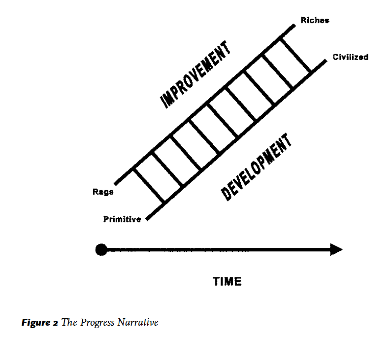
In Malay and Indonesian, development is premised on building. Pembangunan (‘development’) is derived from bangunan (‘building’ or ‘structure’). Bangunan, in turn, is derived from bangun (‘wake up’, ‘stand up’, ‘get up’). The first recorded use of pembangunan I could find was in Al-Imam, a monthly magazine published in Singapore between July 1906-1908, in reference to the rise of Japanese ‘mankind’ (pembangunan umat Jepun).
If development is dependent on building, then they are both central to the rise of a nation.
[50]
L: “The Progress Narrative,” from Eviatar Zerubavel, Time Maps: Collective Memory and the Social Shape of the Past, (Chicago University of Chicago Press, 2003), 16. R: The back cover of Korridor Raya Multimedia: Penjelasan PM, (Kuala Lumpur: Jabatan Penerangan Malaysia, 1997).
Wawasan 2020 was seeped in pembangunan. If Instant Malaysia was made to repair Malaysia’s image as a burgeoning nation in the eyes of international powers, then the 1990s heralded an era where Malaysia was determined not merely to impress them but to join their ranks.
[51]Ong Kar Jin, “The (Up)Ending of the Digital World,” (2021). ❐
While development-as-building was not explicit in the nine strategic challenges laid out in Mahathir’s ‘The Way Forward,’ as it was in the Sarawak Manifesto in 1991
[52]
The announcement of Wawasan 2020 in 1991 spawned a series of sub-ideologies, including the Sarawak Manifesto of 1991 under Barisan Nasional’s Taib Mahmud. One key point in the Sarawak Manifesto that did not appear in the national vision was “sustainable land development,” to turn Sarawak’s small-holder farming land economy to one with large-scale estate developments, timber processing, and a tourism industry. While it touted urban-rural development, its implicit aim was to urbanise inefficient rural areas. Unlike the aspirations of Archigram’s Instant City, the Sarawak Manifesto reinforces the hegemony of the idea of the urban. See more in Postill, How the Iban Became Malaysian, 92.
Notably, another signature project of the 1990s was the Bakun Dam in Sarawak. It proposed to put a land mass roughly the size of Singapore underwater, kept at bay with a monstrous dam of concrete. Protest over deforestation, disease, and the disenfranchisement of indigenous groups went unheeded. The project slowly but surely trudged on – it was completed in 2011, after multiple starts-and-stops.
, it quickly became the definitive toolkit of the state to achieve the status of a ‘developed nation’ by 2020.
Kuala Lumpur was the crucible of these experiments. Now having acquired the catchy abbreviation ‘KL’ – half syllables, double-time – KL was imagined not merely as a meeting point between tin mines and a port but as a new centre of the world. To Mahathir, globalization has erased the geographic lines of a map: it allowed an opportunity for its rewriting in information.
The lines of KL and the net of Instant Malaysia would thus be replaced by the web.
[53]
Irwin Dorros, “The Picturephone System: The Network,” Bell System Technical Journal 50, no. 2 (February 1971): 232. As seen in Tung-hui Hu, A Prehistory of the Cloud, (Cambridge, MA and London: The MIT Press, 2015), xi.
While net (jaring
[54]Also known as JARING, Joint Advanced Research Integrated Networking. Jaring Communications Sdn Bhd, formerly RangKoM (Rangkaian Komputer Network, or Malaysia Computer Network), was Malaysia’s first Internet access provider.
) evoked the nets of fishermen, web had no equivalent word in Malay – it would be unprecedented. Mahathir imagined a “multicultural ‘web’ of mutually dependent international and Malaysian companies… [which] will extend beyond Malaysia’s borders… In short, all parties touched by this ‘web’ will benefit and are enriched through their contribution to it.”
[55]“I see the MSC as a multicultural ‘web’ of mutually dependent international and Malaysian companies collaborating to deliver new products and services to customers across an economically vibrant Asia and the world. I fully expect that this `web’ will extend beyond Malaysia’s borders and out across Malaysia's multicultural links to our neighbours. Component manufacturing can then be done in China, on machines programmed from Japan, with software written in India, and financing coming from Malaysia’s Labuan International Offshore Financial Centre. The product may be assembled in Penang and shipped to global customers direct through our new airport.
“Over time, each of these Flagship Applications will generate a web of world-class and Malaysian companies collaborating to develop and deliver innovative products and services. They will take root and grow in an environment that provides the required lifestyle, infrastructure, laws, and policies. Equally important, I expect links will develop which will connect each of these webs together into one large MSC web. Indeed, it is these links which will allow the MSC to sustain its competitiveness over time. Malaysia is a country with a vision and a strategy to achieve the vision called Vision 2020. Our goal is to attain developed country status by the year 2020. These interlinked webs will allow us to achieve the goals of Vision 2020 by developing a strong services sector to balance our already strong manufacturing sector while helping to improve the productivity and quality of life in the nation.” – Mahathir, “The Los Angeles Conference for Investors on MSC: Global Bridges to the Information Age.” Speech, University of California Los Angeles, January 14, 1997. ❐
In another speech, he continues, “like a spider, [the web] will weave ever more intricate webs of relationships… such a web could be the new model of development for the Information Age.”
[56]Mahathir, “The MSC Investors Conference in conjunction with CeBIT.” Speech, CeBIT 1998 at Hannover, Germany, March 20, 1998. ❐
In Mahathir’s vision, we would all be already entangled.
The web made new political subjectivities. “Web shapers”
[57]With thanks to Yap Lay Sheng for this archive find.
were the new agents for crafting this digital age, applicable to bureaucrats on an e-Government task force,
[58]See more in the comments section of Mahathir’s blog. ❐
enterprising private individuals, and even to companies.
[59]Mahathir, “The Official Opening of Cyberjaya.” Speech, Cyberview Lodge in Cyberjaya, July 8, 1999. ❐
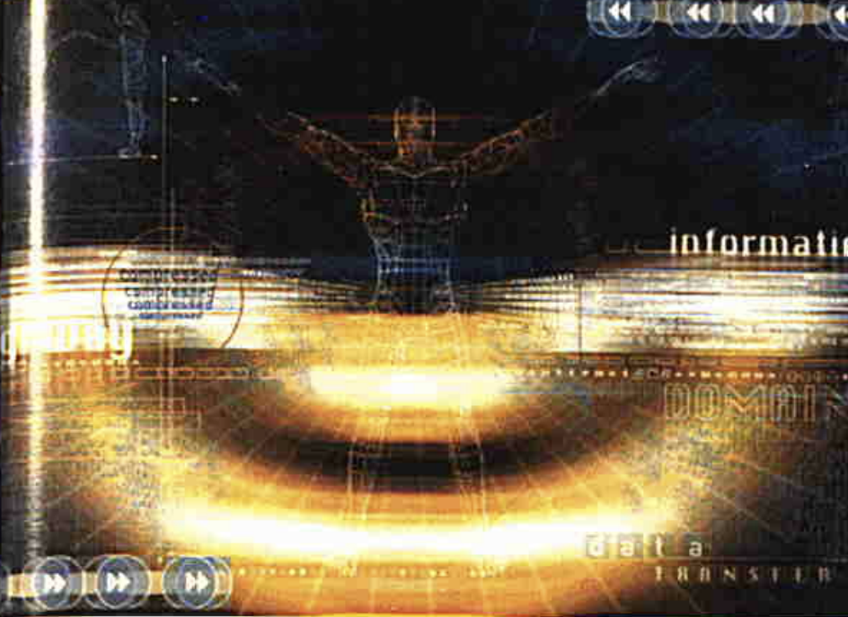
Discontent with merely being a conduit, being a web shapers implied influence. In this age – much like the Instant Malaysia simulator – technology would become an extension of man. In a telling corporate image
[60]
21st Century Malaysia, (Kuala Lumpur: Asian Strategy & Leadership Institute, 2001), 74.
published by the Asian Strategy Leadership Institute (ASLI), a man is placed in the middle of the page, arms raised, and legs slightly spread in the style of Da Vinci’s Vitruvian man. But he no longer exists as corporeal, his body transparent and rendered only in faint lines against an endless void. The brightest parts of the image – and its focus – is not on the subject but on the series of lines and light emanating out of and into the man. These lines are helpfully labelled, “information,” “domain,” “data transmission,” “compressed, compressed, compressed, compressed.” The light shimmers with such brilliance it rewrites the world around it, with the skip-forward and go-backwards buttons glitching into multiples like a time-lapse photograph.
If the web shaper was to be the conductor of an orchestra of information, then he would need “both the physical and the psychological space for creativity.”
[61]Mahathir, “The MSC Investors Conference in conjunction with CeBIT.” Speech, CeBIT 1998 at Hannover, Germany, March 20, 2018. ❐
And “we are not just talking buildings,” Mahathir continued. Infrastructure – both physical and immaterial – pointed the way forward. More than physical structures made for travel, infrastructure promised scale, marrying the physical demands of a growing city with its aspirations for a digital age en masse. Self-sufficient structures would give way to formulaic interdependencies, where each project was both a node in a web and a web itself. Within this logic, infrastructure space becomes “repeatable phenomena engineered around logistics and the bottom line, with elaborate routines and schedules for organizing consumption.”
In this sense, these logics are also “a kind of conjuring, a dramatic performance,”
[63]Anna Tsing, Friction: An Ethnography of Global Connection, (Princeton, NJ: Princeton Univeristy Press, 2004), 57.
a formal and verbal rhetorical language that permeated all the actors on the stage. A litany of megaprojects was approved,
[64]A non-exhaustive list of megaprojects, entangling public and private:
Agarta Universe Theme Park, Johor Bahru
Auto-City, Penang
Asia-America Gateway, Pacific Ocean
Bakun Dam, Sarawak
Balai Seni Negara (new site), Kuala Lumpur
Berjaya Times Square, Kuala Lumpur
Bukit Jalil Stadium, Kuala Lumpur
Bursa Malaysia (Kuala Lumpur Stock Exchange) Building, Kuala Lumpur
Cyberjaya, Klang Valley
Islamic Arts Museum Malaysia, Kuala Lumpur
Klang Valley Integrated Transit System
Kuala Lumpur International Airport, Klang Valley
Kuala Lumpur Tower, Kuala Lumpur
Langkawi International Maritime and Aerospace Exhibition (LIMA)
MEASAT Satellite System, space
The Mines Resort & Gold Club, Klang Valley
Multimedia Super Corridor, Klang Valley
Multimedia University, Klang Valley
North-South Expressway, Peninsula Malaysia
Palace of the Golden Horses, Klang Valley
The Petronas Twin Towers, Kuala Lumpur
Port of Tanjung Pelepas (PTP), Johor Bahru
Proton City, Perak
Pusat Sains Negara, Kuala Lumpur
Putrajaya, Selangor
SMART Tunnel, Kuala Lumpur
Trans-Kalimantan Highway, Borneo
among them the Petronas Twin Towers (1993-1999), and the unrealized KL Linear City (1994-).
The skyline of KL was emblematic of this new psychological space, with its crowning achievement of having not one but two of the tallest buildings in the world. Designed by Cesar Pelli, the former dean of the Yale School of Architecture, the Petronas Twin Towers (colloquially known as KLCC
[65]Known locally as KLCC, which should stand for Kuala Lumpur Convention Centre, but I believe was subliminal messaging for “Kuala Lumpur City Centre.” Or perhaps it is because the mall is named Suria KLCC, and the mall is the unit of interest for the whole building.
) was paid for by oil profits. Clad in stainless steel, it glitters against the sky against the glare of the equatorial sun. Like the Government Offices, it would borrow elements outside Malaysia in a web of influence: the plan of the towers is based on the geometric motif of the Rub-el-Hizb, the Islamic Star, albeit with circles added on. The twin towers are minaret, office, skyscraper, and mall tightly coiled into two packages like a swiss roll. Mahathir famously compared them to what a “box is to a shorties,”
[66]Ong Kar Jin, “The (Up)Ending of the Digital World,” (2021). ❐
a platform from which Malaysia may stand alongside global powers.
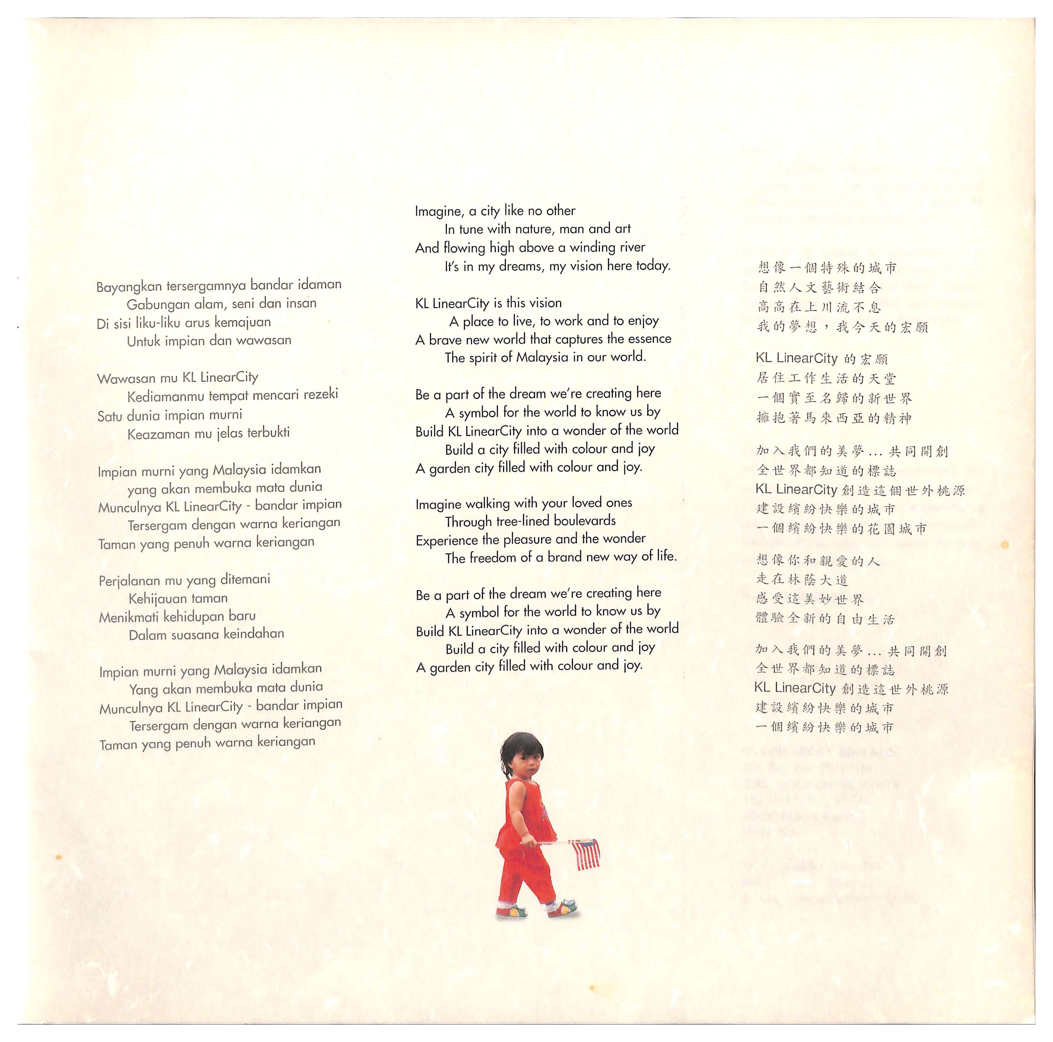
KL LinearCity (KLLC) would be the alter-ego of the Petronas Twin Towers. Touted to be the longest building in the world, LinearCity would be “the happiest place in Asia… Some day someone may beat the KLCC, but no one will beatAA the longest building in the world,” enthused one executive. It is easy to understand the allure of the skyscraper in the modern age – of compactness, of transcendence, of overcoming – but what
[67]With thanks to Surry Schlabs for pointing out precedents for linear buildings in architecture.
are
[68]
Sketch of Edgar Chambless' Roadtown from "The Independent", May 5, 1910. Image from Wikimedia Commons. ❐
the
[69]
Le Corbusier, Plan Obus, Algiers (1930). As seen in Brian Ackley, “Le Corbusier’s Algerian Fantasy: Blocking the Casbah,” Bidoun (Winter 2006). ❐
aspirations
[70]
Peter Eisenman and Michael Graves, Linear City (1965). As seen in “Linear City,” Hidden Architecture. ❐
of
[71]
Paul Rudolph, Lower Manhattan Expressway (1972). As seen in Robert Breugmann, "Paul Rudolph’s Strange Vision of a Cross-Manhattan Expressway (and Other Unfinished Projects)," LitHub, 2020. ❐
the
[72]
Wu Guanzhong, The Great Wall (1986). Image from Wikiart.org. ❐
linear
[73]
Andy Goldsworthy, Storm King Wall. Image from Storm King Art Center. ❐
? Distributed in space, over the expanse of a river, in an instant, LinearCity would not only contain “the majesty and murderous stupidity”
[74]Ben Lerner, 10:04, (New York: Farrar, Straus and Giroux, 2014), 19.
of the time, energy, and labour poured into its body, but also stand strong enough to reconcile the contradictions through its sheer confidence. If KLCC was an exclamation, KLLC was a manifesto. In the words of Manfredo Tafuri on the Le Corbusier’s linear 1930 Plan for Algiers:
“Absorb that multiplicity, reconcile the improbably through the certainty of the plan, offset organic and disorganic qualities by accentuating their interrelationship, demonstrate that the maximum level of programming of productivity coincides with the maximum level of the productivity of the spirit… More precisely, form assumes the task of rendering authentic and natural the unnatural universe of technological precision.”
[75]Manfredo Tafuri, Architecture and Utopia: Design and Capitalist Development (Cambridge, MA: The MIT Press, 1976), 125-6.
LinearCity was an architecture of an age. To make the web a reality, we’d have to draw a big, fat line on the map.
Move along
Arata Isozaki: I was thinking about [the Metabolist] concept of time: time is linear and grows or progresses from the beginning to become a utopia in the end. It’s a linear progression with no…
Rem: No deviation.
- Project Japan, page 40.
The penultimate track on crossover thrash band Pilgrim’s album, Achtung! This is Not a Metal Band from the year 2000, is a 50-second interlude titled “The March on Ampang River.” “You’d have to be crazy not to be scared,” whispers the gruff voice of Tommy Lee Jones, sampling from the 1998 movie “Small Soldiers” where he plays a toy soldier named Chip Hazard who is brought to life by artificial intelligence, but not safety tested due to corporate deadlines. Anchored by a snare, an electronic keyboard plays the melody, beginning with five notes and with a variation as a response. In the regular time of a militaristic march, the song moves on, blind to the variation and reverts to uniformity, repeating the five notes at the beginning. The song ends with another sample from “Small Soldiers.” “It’s a small world after all,” Chip Hazard intones, as the march disintegrates into synthetic, glitchy noise.
LinearCity was troubled from the start, seemingly sustained by the heady cocktail of fantasy and promise of a pay-out. The project was initiated by David Chew Keat Soon, a dilettante who studied engineering at MIT, and the business tycoon Tan Sri Vincent Tan, the lordly founder of Berjaya Corporation and a known crony of Mahathir Mohamad. Chew and Tan were first aligned in 1991 when Indah Water Konsortium Sdn Bhd, a joint venture between them, was awarded a 28-year sewerage concession to overhaul Malaysia’s sewage disposal system.
LinearCity was to be their encore performance. It had rather unheroic origins for such a heroic space: dredging and cleaning the Klang River, which had accrued years of government neglect. On a 12km along the Klang River from Jalan Tun Razak to Puchong, and a small stretch of the Gombak River, Chew and Tan proposed to make a deal with the government. They would clean and fortify the muddy river to mitigate persistent floods, build parking lots, and build a monorail train system, also known as the People-mover Rapid Transit (PRT) system.
[76]The eventual culmination of the KL Flood Mitigation Project was the Stormwater Management And Road Tunnel (SMART), a 9.7km long stormwater drainage tunnel that doubles as a highway, completed in 2007.
In return, Pripadu Sdn Bhd, a joint-venture company owned by Chew and Tan and capitalized for RM2, would be awarded the rights to build around and above the Klang River.
[77]The land was controlled by the Government under the National Land Code (NLC) and the Waters Act 1920 (A418) – to legally build, developers recommended that the government alienate the river reserve to Pripadu.
In the absence of space ripe for development in a city as crammed as central Kuala Lumpur, they would make space into property: a network of commercial and residential spaces would sit on top of the river itself. Where others saw air, they saw strata titles and the longest building in the world. The Klang River began as a trading hub; now, it too would be traded.
Huat Lim, a young architect who had just moved back to Kuala Lumpur, was appointed as the architect for the project. Fresh from a stint at Norman Foster’s office and his education at the Architectural Association, Huat saw the project as an opportunity to remake public space in Kuala Lumpur, so that the city’s “heart starts to beat again.”
[78]Interview with Huat Lim, October 7, 2020.
Rather than seeing the privatization of the riparian zone
[79]With thanks to KS Jomo for pointing this out.
around the river as an irreversible infringement on public space, Huat believed that it was the only way to return the riverbank to the people as habitable space. In the logic of late capitalist Malaysia, it was easier to make a deal with the lesser devil of developers than to attempt to affect any change within the protected ranks of government. Years of neglect had made the Klang River acrid, muddy, and unsuitable to the liberal vision of a modern city-dweller taking a relaxing stroll along its bank. In the eyes of Wawasan, the river provided neither physical nor psychological space for the new Malaysian, never mind the 1,000+ families who lived in Kampung Pasir Lama, Kampung Kicap, and Brickfields and would have to be evicted for the project to continue.
LinearCity saw the return of a familiar figure in the making of Malaysia: Archigram. Huat, having taught with Peter Cook and Ron Herron of Archigram at the Bartlett in London, pulled his mentors in to work on the project. Herron Associates was even listed as a “Future Systems Consultant” in the original masterplan. Archigram’s ideas, anachronistic in the West by the 1990s, gained new relevance in a nation seeking to build information into its infrastructure. Working over bottles of white wine,
[80]Interview with Huat Lim, October 7, 2020.
they aimed to “achieve… scale in one quantum leap.”
[81]Pripadu, Kuala Lumpur LinearCity Volume One: Masterplan and Architectural Report, (Kuala Lumpur: Pripadu, 1994), 4. Hereafter “KLLC Masterplan.”
[82]Interview with Huat Lim, October 7, 2020.
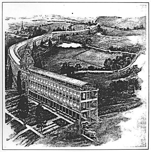
In 1994, Huat, along with Cook and Herron, produced the first iteration of the LinearCity Masterplan for Pripadu. LinearCity touted itself as the “spine” of the city. KLCC would be “the Head”, Masjid Jamek and the historical area of the confluence would be “the Heart” while the surrounding old town areas would be “the Body,” and finally the industrial zones of Puchong and OUG would be “the Tail.” Instead of driving around town, the architects imagined that you would park your car in one of the 28,000 parking lots
[83]The parking lots were supposedly ordered by none other than Prime Minister Mahathir Mohamad himself.
offered and ride the Monorail up and down the spine of the city. Instead of the metaphor of arteries and blood usually associated with highways, the spine – reminiscent of the language of Japanese Metabolists – carries information in electrical signals. Each firing of a neuron is an action potential.
Embedded from the Head to Tail was the potential of the LinearCity Information Highway. It looked toward the future, with a keen awareness of its own obsolescence: “The highway is permanent, the services transient and its usage is market led.” With cables running the length of the development and “switching gear servicing each building with branching connections to the surrounding city,”
[84]KLLC Masterplan, 56.
it would serve as case study and case-in-point for the line-as-web. One could live within the fantasy of LinearCity. The proposed (and later realized) National Registration Identity Card (NRIC) would contain fingerprint biometric data and digital currency on an in-built chip, all embedded in a thin piece of plastic. The MyKad, as it is now known, was imagined to be the one-stop access to LinearCity. Swipe in to ride the Monorail, to pay for your shopping at the mall, to withdraw money from the bank, to check into your office. Swipe out when you’re done.
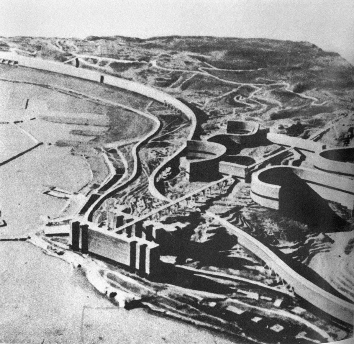
It would take minimal architecture to contain this new way of living. Like its progenitor Instant City, LinearCity was a generic concept. In fact, in 1997, Huat would once again propose to build the same network of structures on Sungai Temiang, the main waterway in Seremban. Huat offered not buildings, but a range of “armatures, accessories, and components.”
[85]KLLC Masterplan, 35.
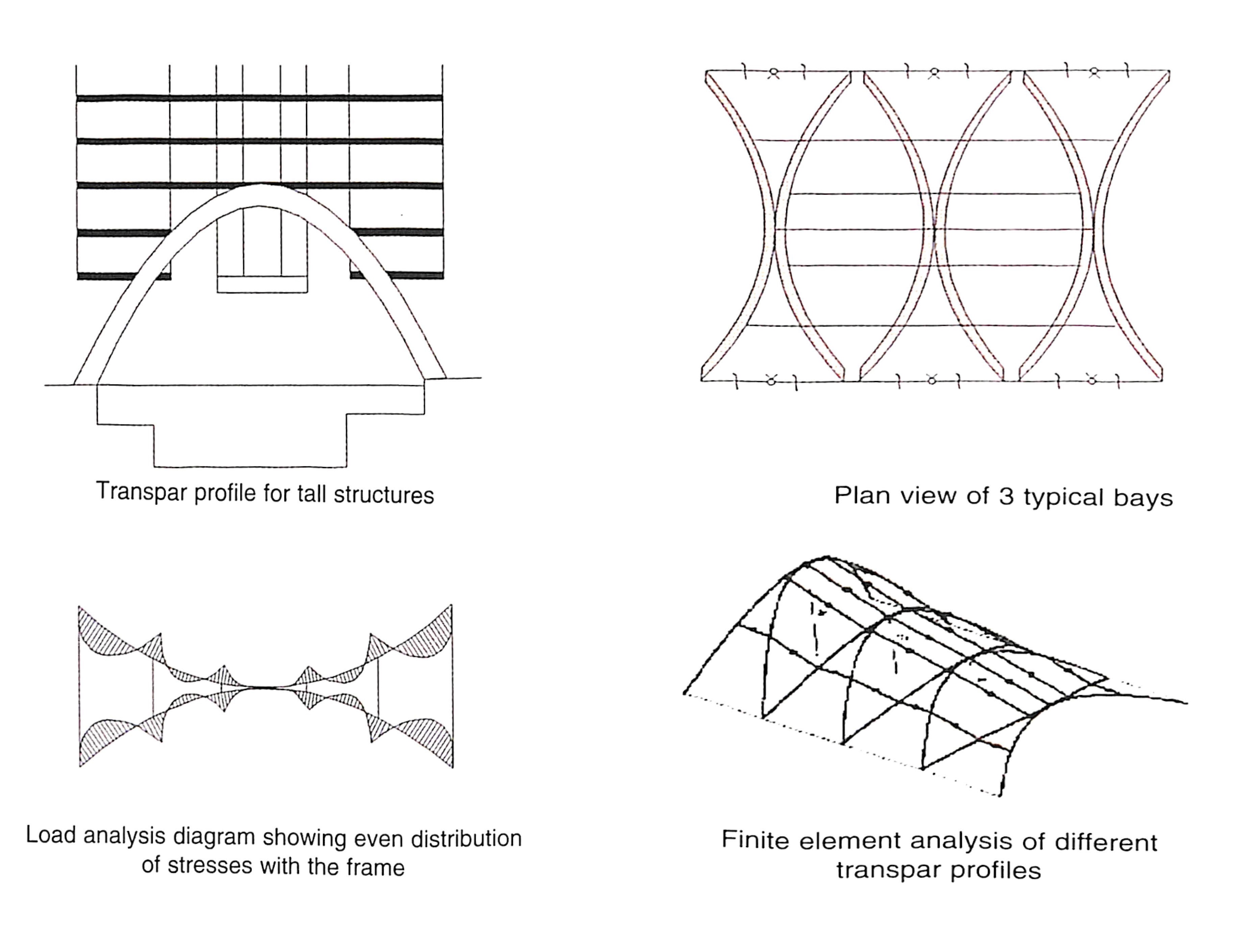
Suspended above the river with a series of Pringle-like transpar frames
[86]
KLLC Masterplan, 38.
developed by Ove Arup, his proposed structures were so “fine, filigree, and non-threatening”
[87]Interview with Huat Lim, October 7, 2020.
that he imagined they could be blown away at any moment.
[88]
KLLC Masterplan, 35.
Read without scale, they could almost be mistaken for telecommunication towers.
LinearCity took one step further than the simulator of Instant Malaysia. If the simulator of Instant Malaysia was meant to dissolve a user into a stream of information, then LinearCity wanted to wield it. Nowhere is this more clearly seen than in the proposed Hydrophonic Parks,
[89]
KLLC Masterplan, 54.
one at Central Market near the confluence of the Klang and Gombak River
[90]
KLLC Masterplan, 61.
, and the other at Puchong. Rather than cover up the river, “KL LinearCity will enhance the river’s prominence as a feature of the city.”
[91]KLLC Masterplan, 30.
More than a promenade to walk on, LinearCity would put the river to work, using “siphonic technology to draw energy derived from water.” Meanwhile, a station would control satellite and microwaves, with an “intelligent solar system” and light-sensitive cladding panels. In Huat’s telling of the story of LinearCity, this was the early days of sustainable architecture in Malaysia, coherent with the “environmental design” promulgated by Ken Yeang through the 1980s and 1990s. Yet this was not the gardens-in-the-sky
[92]
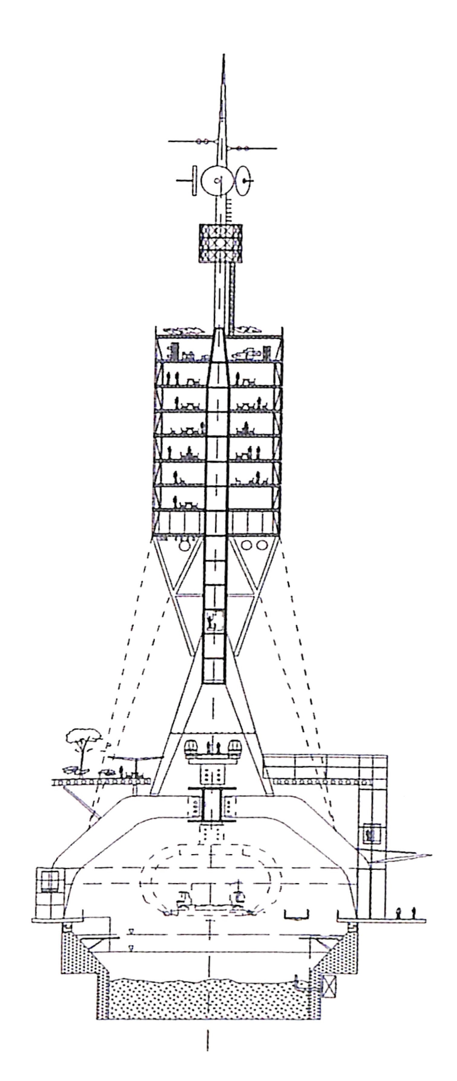
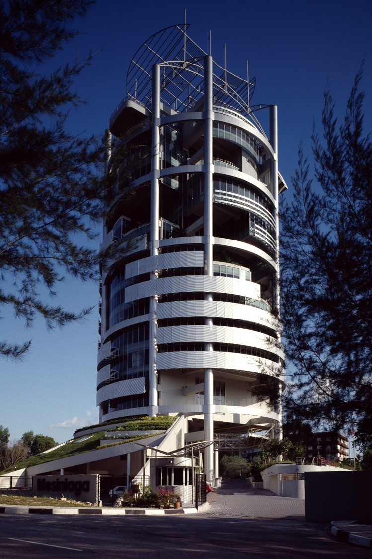
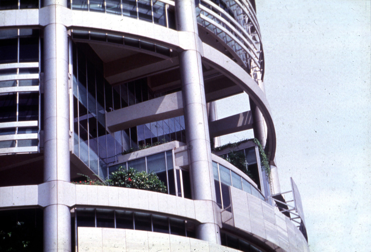
Photographs of Ken Yeang’s Mesiniaga Tower (1992). From Wawasan 2020 Collection at Malaysia Design Archive.
proposed by Yeang, where nature and technology were brought together to offset one another. The hydrophonic park rendered environment as information, where air, water, invisible waves, and the sun were passed through a system of utility. Linear City took the dream of Instant Malaysia, scaled it up and adjusted it to the needs of a private corporation.
The building could operationalize information, and it aspired for its occupants, who would ideally be web shapers, to be able to do so as well. In another section, the report – sounding awfully like algorithmically-generated text
[93]See more at Chuah Chong Yan, Y. L. S., and Zhi Wee, “At the Dawn of the New Millennium, Our Span of Control is Almost Limitless,” (2021). ❐
– continues, “Occupants need to have the semblance of decision-making… this requires clarity and simplicity in environment-tempering. The concept should be responsive intelligence which allows an interaction between user and building and the degree of learning which is the essence of fuzzy logic control.”
[94]KLLC Masterplan, 57.
In the words of Deleuze, “controls are a modulation, like a self-deforming cast that will continuously change from one moment to the other, or like a sieve whose mesh will transmute from point to point.”
[95]Gilles Deleuze, “Postscript on the Societies of Control,” October, Vol. 59 (Winter, 1992), 4.
Control would no longer be totalising, but would operate like a switch, drawing geographies of connection and disconnection. In Wawasan Malaysia, we would all be points of, agents of, and subject to control.
Like the ASLI image of the web shaper as Vitruvian man, information was the protagonist. Architecture would become just a frame, a window, a background. If the promise of the simulator was as a prosthetic to plug a user into a different world, LinearCity wanted to render invisible the interface between user, software, and hardware. Its architecture was one of reduction, until it would threaten to disappear. Dematerialized with light membrane walls, held together by tension rods on transpar spans, and represented in the briefest lines in drawing, it was imagined as an impermanent system. Perhaps even the end of architecture itself.
A perspectival collage
[96]
KLLC Masterplan, Inner Cover.
– one of two produced in this document – suggests a bias toward the horizon rather than the interior of the building. A pillar and a mural cut off the perspective within the building. The view outside the floor-to-ceiling glass walls is the focus of the image: beyond, dense vegetation gives way to a view of other buildings in KL. LinearCity itself is a promenade made for looking outward, a platform from which to absorb the city. By reducing the foreground, the horizon becomes ripe for picturing: a yellow helicopter, a protruding helipad, jaunty circles of colour in the sky. Curiously, an oval with a gradient from orange to yellow to white occupies the far right of the picture. It hovers between the inside and outside, standing outside perspectival space.
When lines grow from drawing to space, frictions emerge.
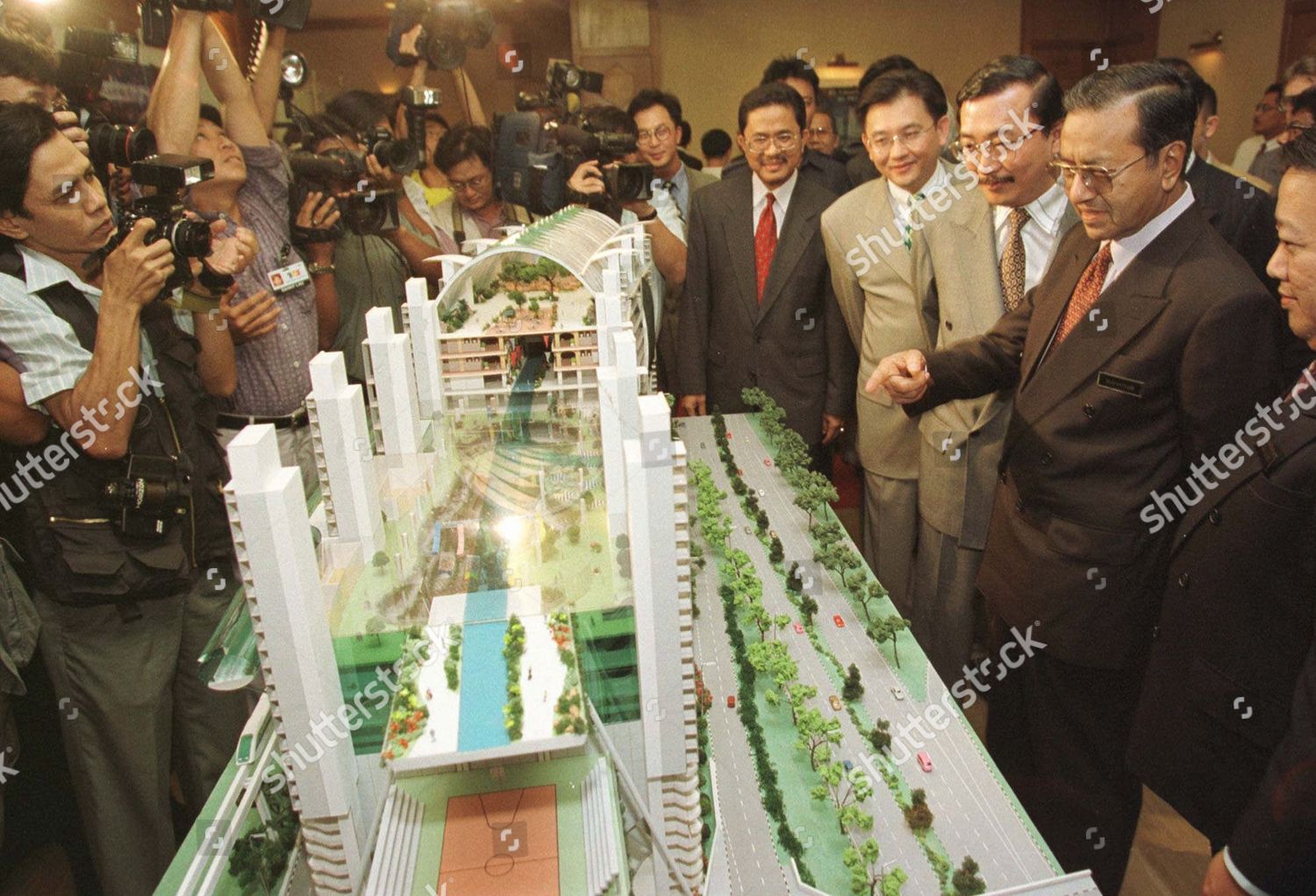
Huat, Cook, and Herron’s vision of LinearCity was eventually passed over. In Huat’s telling of the fable of Linear City, the greed of developers led to an endless cycle of unfulfilled consumption, and the project increasingly became about maximizing plot ratio and built-up area and being the longest building in the world.
[98]
Mahathir looks at a model of the 1996 design for KL Linear City. ❐
The already complicated development took on additional layers
[99]
The formal inspiration for this essay. KL LinearCity, KL LinearCity: Your Global Address in Asia, (Kuala Lumpur: KL LinearCity, 1996), 1. Hereafter "KL LinearCity 1996."
– hotels, boat rides that referenced Macao referencing Venice. Huat eventually left the project.
Under this new direction, LinearCity materialized as building.
[100]
KL LinearCity 1996, 3.
Headed by starchitect Santiago Calatrava, the thin lines of LinearCity hardened into solid walls, metal rails, and glass walls so heavily tinted it was nearly opaque. The 28,000 parking lots in the original proposition became 40,000. A theme song was developed.
[101]
KL LinearCity 1996, 22.
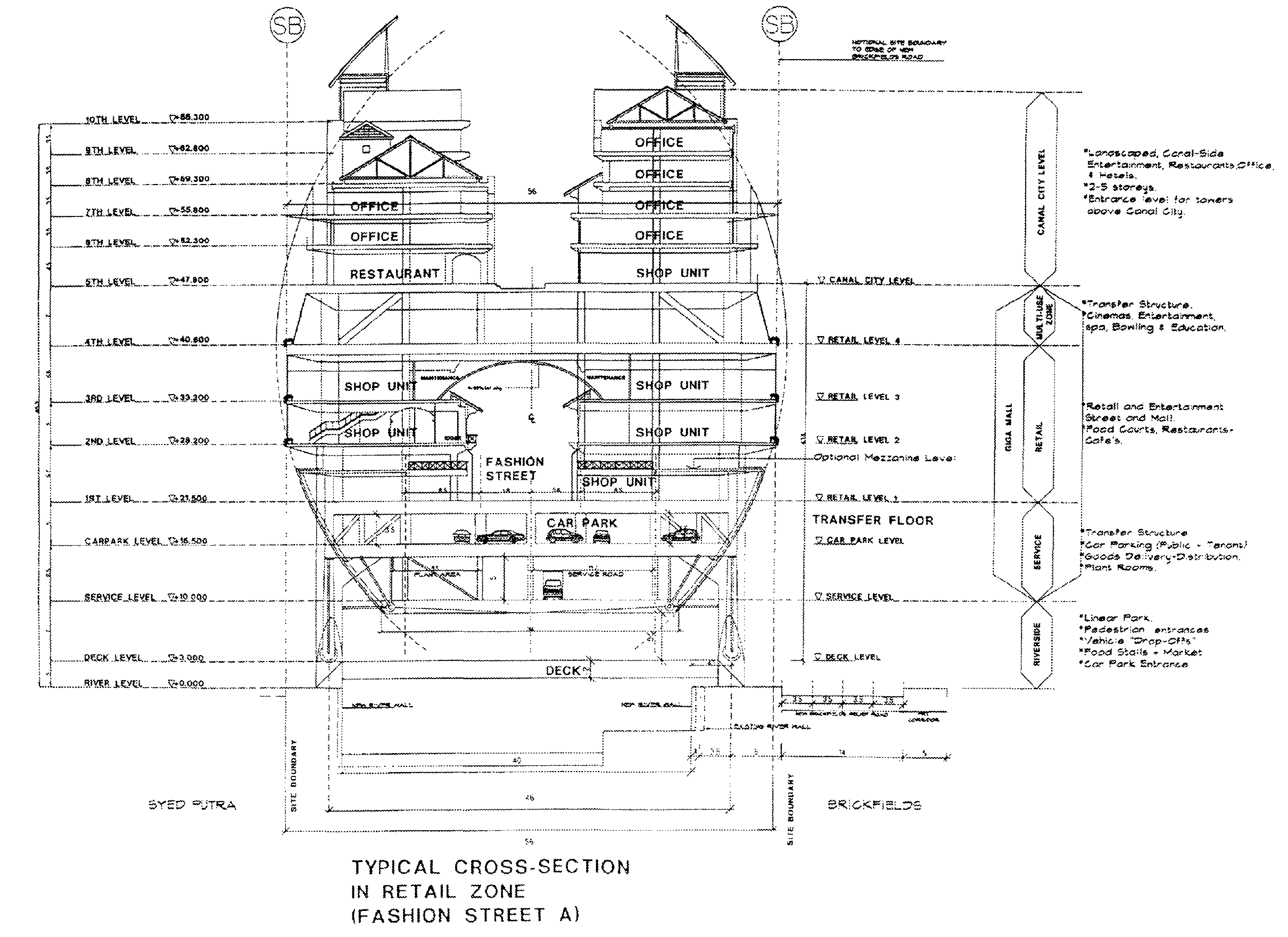
Chief among these new additions were GigaWorld,
[102]
“GigaWorld, a typical cross section at the retail zone.” As seen in David Chew, “Vision of a 21st-century Public Place,” in Public Places in Asia Pacific Cities: Current Issues and Strategies, ed. Pu Miao, (Dordrecht: Springer Science+Business Media, 2001), 337.
a bloated 2.4km long “unique urban commercial and tourism centre.” Colloquially termed “the Egg,” GigaWorld would be “a monumental urban landmark symbolizing in one great gesture the ties of man to nature.”
[103]Izat Arif and Ellen Lee, “First Day Cover for Karya Seni Arca Awam – 2021,” (2021). ❐
[104]KL LinearCity 1996, 9.
In other words, it was a mall.
The 1997 Asian Financial Crisis was the death knell of the project. With Berjaya’s coffers emptied, the government asked to step in to complete the RM 2.2 billion monorail project while Vincent Tan would be free to pursue Linear City, as reported in the Wall Street Journal by economist KS Jomo.
[105]KS Jomo, “Malaysia Props Up Crony Capitalists.” Wall Street Journal, December 22, 1998.
In late 1998, Vincent Tan sued KS Jomo for an amount of RM 250 million on account of defamation. The case was dropped only after a decade.
Hegemonic projects “require and reproduce their own outsides.”
[106]Reinhold Martin, Utopia’s Ghost, (Minneapolis and London: University of Minnesota Press, 2010), xiii.
Three PPRs (Program Perumahan Rakyat, a low-cost government housing project
[108]The three PPRs and their corresponding units provided are: PPR Seri Anggerik (KL Linear City I) – 316 units, PPR Pantai Ria (KL Linear City II Fasa I) – 1264 units, and PPR Seri Cempaka (KL Linear City II Fasa II) – 632 units.
), the underutilized Monorail, and supposedly, a few shophouses in Brickfields that I have yet to be able to identify. When Linear City was shelved, more than 1,000 families who agreed to move from the riverbank area were left in limbo: they were promised medium-cost housing in Bukit Jalil, but by 2002 found the same plot of land occupied by a high-rise apartment.
The end of the line
“If the end might be predicted, or indeed had arrived, then the future was to be bereft of all but repetition.” – Anthony Vidler, Histories of the Immediate Present, 194
We began from a mall and a grid. We ended with the failed promise of a web, and a mall.
Yet, the grid has never truly disappeared. The grid is what allows perspectival drawings of linear city, and the infinite column of the simulator of Instant Malaysia. The past is not forgotten, merely reconstituted.
The aspirations of colonial officers, of Instant Malaysia, of LinearCity, all wished to step outside time. Whether it was in the overcoming of nature, the limits of the body, or of elements itself, the promise of utopia is in transcendence. Yet in an ironic twist, “the specificity of these articulations and collaborations also limits the spread and play of scale-making projects, promising them only a tentative moment in a particular history.”
[1A10]Tsing, Friction, 56.
Putting to paper, drawing on a map, or rendering in a digital drawing necessarily confines the universality of utopia to particularity. It would be far better for a project to exist in noise, in perpetuity, in delay.
The River of Life is the latest megaproject touted to “rejuvenate” the Klang River. With a price tag of RM4.4 billion, like its predecessors, it has been repeatedly pushed. These dreams, constantly delayed, are always just out of reach.


